or


Results for mapping and  
Showing 1 – 10 of 2750
For ultrasonic or other mapping systems which use PPI scan, it is desirable to convert the data to a raster scan format for, say, T.V. display. This may be achieved by conversion in a frame store. It is here proposed to time the PPI scan so that points interrogated by the effective receiving beam lie also on line of a cartesian matrix in the mapped region which correspond to the raster lines of the display thus the conversion is directly achieved.
Design forms for wide-field mapping lenses are disclosed wherein limitations on resolving power attributable to monochromatic aberrations have been minimized, wherein chromatic aberration has been minimized over a broad wavelength band and has been reduced to zero for paraxial marginal rays at three discrete wavelengths, and wherein chromatic variations of the monochromatic aberrations (particularly chromatic variation of coma) have been substantially eliminated. Each of the lenses disclosed has…
A method for mapping the crystal structure of a diamond comprises placing the diamond in a beam of monochromatic laser radiation, filtering the resultant scattered Raman radiation, and measuring the intensity of the filtered radiation at one or more different orientations of the diamond which may be compared with records of known diamonds to identify the diamond.
The present invention relates to a method for topographically mapping the surface of the Earth under utilization of measuring the altitude by means of radar, and under further utilization of a synthetic aperture for the radar, as well as an electronically controlled antenna lobe. In accordance with the preferred embodiment of the present invention, it is suggested to conically pivot the antenna lobe around a nadir, whereby pivoting of the center line follows a path such that the line constitutes…
This invention describes an analog system for the automation of the stereocompilation process and for producing contour maps and orthophoto maps. It employs a combination of coherent optical and electronic techniques for the correlation of stereophoto pairs and thus the computation of parallaxes in the photogrammetric sense, for the selection of specific parallaxes, and for the production of contour maps and orthophoto maps. The system in a basic form reproduces perspective contours of the image…
A radar mapping technique employing a synthetic aperture radar in conjunction with a correlator for directing an object moving in mid air to a desired point on the ground, which point is determined by correlating direct and indirect return signals from the ground and through the moving object respectively.
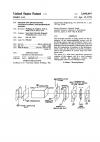
A method of producing a road-mapped image of a body portion for monitored guidance of a catheter therethrough, the method including providing a first X-ray transmission frame of the body portion, injecting contrast-enhancing material into a blood vessel in the body portion, irradiating the body portion with X-ray radiation for a first irradiation session, producing a series of second X-ray transmission frames of the body portion during the first irradiation session, forming a series of third, su…
A subbottom rock mapping probe for measuring the thickness of a sediment er located on the bottom of a body of water comprising an automatic, downwardly extending, telescoping probe that is gimbally connected to a support member. Water is forced through the probe to disperse the sediment impeding the probe’s downward extension. Recording equipment and related measuring devices measure and record the depth of penetration of the probe into the sediment layer from an initial or reference position.
A seafloor mapping system utilizing echo signals from a pair of towed, silooking sonar transducers to generate in real time a roll of photographic film which after conventional processing can be directly viewed in a stereoscope to produce a three-dimensional illusion of seafloor topography.
A method of establishing yield and moisture content maps involves the continuous recording of yield of moisture content of a harvested crop, as a harvesting machine traverses a field. The recorded yield or moisture content is associated with data from a positioning system, in order that a map of yield or moisture content across the field can be generated. The yield or moisture content is compared with a second measurement of yield or moisture content, and a correction factor is determined. The c…
1 2 3 4 5 6 7 8 9 10
 
 
About |  FAQs |  Terms & Disclaimer |  Link to Us |  Contact Us